Showing posts with label Joshua's Bride. Show all posts

Wednesday, November 30, 2022

Survey Markers by Zina Abbott


Survey markers are objects placed to mark key survey points on the Earth's surface. They are used in geodetic and land surveying.

Geodetic, or geodesy, refers to accurately measuring and understanding the earth’s geometric shape and size, its orientation in space, and gravity.  As for land surveying, this becomes necessary—not only to create more accurate maps, including topographical maps, but also to mark off land boundaries.


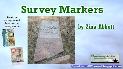
Survey markers are used to mark national and state boundaries, such as this 1877 marker on the Arkansas-Oklahoma state line.


This survey marker was originally upright. It marked the eastern 1893 Oklahoma Land Run boundary.


A benchmark is a type of survey marker that indicates elevation (referring to a vertical position). Horizontal position markers used for triangulation are also known as triangulation stations. Considering the earth is a globe, not flat, and contains mountains and valleys, these details must be accounted for through triangulation.


Survey markers are also called survey marks, survey monuments, or geodetic marks. My husband, who worked almost his entire career in one aspect or another of engineering construction, called them shiners.


This particular shiner is next to Merced River inside Yosemite National Park, just after entering the toll gate on Highway 140. There is a small rest stop there. While waiting for me one year, he wandered out over the rock that overlooked the river and was pleased to find this shiner firmly embedded in the stone.

1855 Geodetisch station at Ostend, Belgium used for triangulation

Survey markers were often placed as part of triangulation surveys, measurement efforts that moved systematically across states or regions, establishing the angles and distances between various points. Such surveys laid the basis for map-making across the world. 
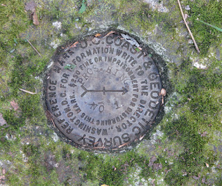
Located on peak of Prospect Hill-Wompatuck State Park, Hingham, MA
 

All sorts of different objects, ranging from the familiar brass disks to liquor bottles, clay pots, and rock cairns, have been used over the years as survey markers. 

Some show the meeting points of three or more countries. In the 19th century, these marks were often drill holes in rock ledges, crosses or triangles chiselled in rock, or copper or brass bolts sunk into bedrock. 


 Today in the United States, the most common geodetic survey marks are cast metal disks with stamped legends on their face set in rock ledges,


embedded in the tops of concrete pillars,or affixed to the tops of pipes that have been sunk into the ground. These marks are intended to be permanent, and disturbing them is generally prohibited by federal and state law.


Some old markers were buried several feet down to protect them from being struck by ploughs or disturbed by other means. Occasionally, these buried marks had surface marks set directly above them.

This year, it was my research for two books set in the new Oklahoma Territory that was formed as a result of the land runs that led to my research on survey markers.

In 1871, the internal format of Oklahoma, then the Indian Territory, began to take shape. Based on Thomas Jefferson's standard United States public land survey system of townships, ranges, sections and quarter sections, an Initial Point was selected and a grid work of north-south and east-west lines was established. The entire Indian Territory was surveyed from a "bearing point" located one mile south of Fort Arbuckle and eight miles west of present-day Davis.

Survey crew Cherokee Strip (Outlet)

I have not discovered exactly what style of survey marker was used when the Cherokee Outlet was divided into quarter sections or city lots for those new cities that were planned in preparation for the 1893 land run. I’m sure they were set in a manner to avoid being disturbed or removed. 

However, in my book, Joshua’s Bride, my fictional heroine, Rose Calloway, attempted to secure the survey marker on the back, out of the way corner of the homestead plot she claimed. Being told by two of her neighbors who shared the corner that it was illegal for her to remove the survey marker did not deter her from digging it up. She was determined to keep usurpers from coming onto the back portion of her land and copying down the coordinates in an effort to claim the homestead plot for themselves. Here is an excerpt from the book:

         “You need to put it back, right away. In fact, give it me. I’ll find a surveyor and have him reset it.” The clerk reached for the pole.

         “No!” Rose twisted to keep the post away from his reach. “It’s my pole that goes to my property. Well, mine and three of my neighbors.”

         “Sir, you won’t need to go to all that trouble.” Joshua pulled Rose behind him and stepped to squarely face the clerk. This woman needs a keeper. “She’s with me, and I’ll help her return it where it goes.”

         “She your wife?”

         “No, sir, she’s my fiancé. We have one more matter of business to see to while we’re here, and then I’ll return her home and help her reset it.” The word fiancé was out of Joshua’s mouth before he even thought about it. He did not know how she felt about it, but, he reasoned, it was better for her reputation to be traveling in the company of a fiancé than a man with whom she had a casual acquaintance. He held the clerk’s gaze.

         “Is there a problem, Charlie?” A deep voice sounded as an older, thick-shouldered man with a deputy marshal’s badge on his chest approached.

         “This woman here—” The sputtering clerk waggled a finger at Rose as he turned his head to toward the deputy marshal.

         “There’s just been a little misunderstanding, marshal.” With a smile that lit her entire face, Rose stepped back to Joshua’s side. “I brought this survey post with me to help me register my land. You know, to prove I am the one who has the claim on that particular homestead? However, the clerk just told me I wasn’t supposed to take it out of the ground. I assured him I will take it home and put it back where it goes.”

         Joshua shifted his gaze between Rose, the deputy marshal with the thoughtful expression, and the clerk, who rolled his eyes. He resisted the urge to roll his eyes, too. I want to be her keeper. He cleared his throat. “As I was telling this gentleman, here…” he gestured toward the clerk. “Now we know the pole needs to stay in place, we’ll leave as soon as we finish one more item of business and go directly to the property where this survey post goes. I’ll help her get it set in the ground properly.”

         “Sounds reasonable to me.” His hands on his hips, the deputy marshal pressed his lips together and nodded. “Work for you, Charlie?” He turned to the clerk with an expression that did not invite a challenge.


         As he stared at the deputy marshal, Charlie swallowed. “If you say so.” Then he stiffened his posture as he turned and scowled at Rose. “Swear you’ll put it back as soon as you return to the property.”

         “I don’t swear, sir.” Rose straightened her spine and lifted her chin. “But, I will promise. I will return home and put the pole back where I found it.”

Joshua’s Bride is available for sale as an ebook and a paperback. It is also available at no additional cost with a Kindle Unlimited subscription. You may find the book description and purchase link by CLICKING HERE


         Rose’s sister, Marigold Calloway, claimed two lots in the town of New Ponca that was created as part of the same 1893 Cherokee Outlet Land Run. Even the boundaries of many town lots are marked with survey markers. You may find the book description and purchase link of Marigold by CLICKING HERE


Sources:

https://en.wikipedia.org/wiki/Survey_marker

https://libraries.ok.gov/state-government/corner-monuments/

https://en.wikipedia.org/wiki/1877_survey_marker_48


Friday, July 1, 2022

Fort Gibson, Oklahoma by Zina Abbott


I have read about and visited Fort Smith, Arkansas, which is just across the river from Oklahoma. I knew it played a large role in overseeing law and order within Indian Territory and, later, Oklahoma Territory. Fort Gibson, I discovered, was also right in the thick of things during much of early Indian Territory history.


In 1824, several years after the acquisition of the Louisiana Purchase but prior to the removal of the Five Civilized Tribes from east of the Mississippi River, marked the beginning of Fort Gibson. 


Colonel Matthew Arbuckle, who commanded the 7th Infantry Regiment (United States) from Fort Smith, Arkansas, moved some of his troops to establish Cantonment Gibson on 21 April 1824.  When it was constructed, the fort was farther west than any other military post in the United States. It formed part of the north–south chain of forts that was intended to maintain peace on the western frontier.

The US Army named the fort for Colonel (later General) George Gibson, Commissary General of Subsistence. It is located next to the modern city of Fort Gibson in Muskogee County, Oklahoma, where the three forks of the Arkansas, Verdigris, and Grand Rivers converge south of the Ozark Plateau. It was part of a series of forts established by the United States to protect its western border. It was part of a series of forts which the United States established to protect its western border and the land of the Louisiana Purchase. The troops constructed a stockade, barracks, other facilities, and roads. The fort provided the earliest known weather records in Oklahoma thanks to the post surgeon who began taking meteorological observations in 1824. It also served as a starting point for several military expeditions that explored the West.


The fort also served as an outpost on the Texas Road connecting settled Missouri with the new country of Mexico after it declared its independence from Spain in 1821. During the Texas Revolution against the weak Mexican government, the Army sent most of the troops stationed at Fort Gibson to the Texas border region.


Map of traditional Osage lands since 1700s

The Army designated the cantonment as Fort Gibson in 1832, reflecting its change from a temporary outpost to a semi-permanent garrison. Soldiers at Fort Gibson increasingly dealt with Indians removed from the eastern states to Indian Territory by being called upon to keep the peace between the indigenous Osages and Cherokees. When the Cherokees were first removed from North Carolina, the first bands to arrive were given land right in the middle of traditional Osage territory. The Osage did not accept the incursion well. The newcomers, not happy about being forced to leave their traditional homeland, complained about hostility from the Osage Nation and other Plains Indian tribes indigenous to the region.

Fort Gibson Commanding Officer Quarters

The fort figured prominently in the Indian removals. At the height of Indian removal in the 1830s, the garrison at Fort Gibson ranked as the largest in the nation. Notable American soldiers stationed at (or at least visiting) Fort Gibson include Stephen W. Kearny, Robert E. Lee, and Zachary Taylor. The Army stationed Jefferson Davis and more than 100 West Point cadets at the fort. The Army also assigned Nathan Boone, son of Daniel Boone, to the post. After leaving Tennessee, Sam Houston owned a trading post in the area before later moving to Texas.


Originally assigned Five Civilized tribes Indian Territory

At a bitterly contentious meeting at Fort Gibson in 1836, the majority faction of the Muscogee (Creek) reluctantly accepted the existing tribal government under the leadership of Chilly McIntosh, son of William McIntosh, and his faction. Colonel Arbuckle tried to prevent intratribal strife within the Cherokee, but Chief John Ross and his followers refused to acknowledge the government that earlier "Old Settlers" had established in Indian Territory. After suing for peace in the Florida Seminole Wars against the United States Army, many of the Seminole, dispirited and about their defeat, arrived in Indian Territory. Officials at Fort Gibson managed to prevent bloodshed and disunity among them.

When Colonel Arbuckle left Fort Gibson in 1841, he reported that despite the arrival of 40,000 eastern disgruntled Native Americans, "I have maintained peace on this frontier and at no period have the Whites on our border or the Red people of this frontier been in a more perfect state of quiet and Security than they enjoy now." The removed Native American nations gradually lost their desire for American military protection.


Postcard of reconstructed Fort Gibson

Fort Gibson was occupied through most of the Indian removal period, but then abandoned in 1857. This came about when, in the 1850s, the Cherokee complained about the liquor and brothels at Fort Gibson. In an effort to prevent the sale of alcohol to their people, they urged Congress to close Fort Gibson. The War Department honored their request.

The fort was reactivated during the Civil War. It was renamed Fort Blunt and served as the Union headquarters in Indian Territory. The army stayed through the Reconstruction and Indian Wars periods, combating the problem of outlaws and squatters.

Missouri-Kansas-Texas RR, also known as the Katy

In 1872 the Tenth Cavalry reoccupied Fort Gibson. Soon after, workers were sent to the area to build the Missouri–Kansas–Texas Railroad from Baxter Springs—the first Kansas "cow town"— to the Red River crossing at Colbert's Ferry, which was in Indian Territory, along the Texas border. The railroad improved transportation of cattle and beef to the east as well as shipping of goods from that area to the West. The cavalry from Fort Gibson was used to police the camps of local workers. Soldiers also tried to manage threats from outlaws, white encroachment on Indian lands, intra-tribal disputes, and other issues. The size of the garrison varied with the workload.

The Kansas and Arkansas Valley Railway built track through the area in 1888, and the town of Fort Gibson, Oklahoma began to develop. In the summer of 1890, the Army abandoned the military post of Fort Gibson, this time for good, although troops occasionally camped at the site when unrest brought them to the town of Fort Gibson. Eventually, the civilian town expanded into the former military grounds of the fort.


Fort Gibson Barracks -photo taken 1934

Fort Gibson was active on and off from 1824 to 1888. The fort succeeded in its peacekeeping mission for more than 50 years, as no massacres or battles occurred there. Abandoned in 1890, the fort was later the headquarters of the Dawes Commission which was tasked with enrolling members of the Five Tribes, particularly the Cherokee Freedmen.


My most recently published book is Joshua’s Bride, the first book in the Land Run Mail Order Brides series set in Oklahoma Territory about the same time Fort Gibson ended its service as a fort in Indian Territory. Although on opposite sides of the current state of Oklahoma, it has been interesting to learn more about the early history.

To find the book description and purchase options for my book, please CLICK HERE


Sources:

https://www.okhistory.org/publications/enc/entry.php?entry=FO033

https://en.wikipedia.org/wiki/Fort_Gibson

https://www.okhistory.org/sites/fortgibson

Monday, May 30, 2022

Memorial Day - When It Began by Zina Abbott


Every year since the end of the Civil War, Americans celebrate the lives that were lost in war.

The practice of strewing flowers on the graves of those lost to battle started centuries ago in early Rome. The practice continued in parts of Europe. With so many dead as a result of the Civil War, and with so many buried in less-than-ideal situations, the desire to pay tribute to those who gave their all.  

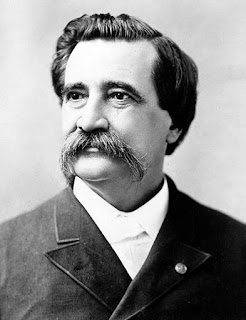
General John Logan

With his General Order Number 11, dated May 5, 1868, General John Logan called for a nationwide observance which would be known as Decoration Day. It was first observed nationally on May 30, 1868.

The objective was “for the purpose of strewing with flowers or otherwise decorating the graves of comrades who died in defense of their country during the late rebellion.” In addition to the decoration of graves, Decoration Day was also to be observed with “fitting services and testimonials of respect as circumstances may permit.”

May 30, 1873 Decoration Day at the Old Amphitheater at Arlington Cemetery  President Ulysses S. Grant and General John Logan

Veterans and their loved ones, as well as widows, orphans, and other bereaved, responded with great enthusiasm. That year, 183 cemeteries in 27 states celebrated Decoration Day, and observance only grew in the years that followed.

General James Garfield (not yet president) gave a speech at Arlington National Cemetery with other generals. During the observance, 20,000 graves of Union and Confederate soldiers were decorated.

Fort Stevens near Washington D.C. had a small cemetery with 40 soldiers buried there. One of the soldiers buried was the son of a widow who lost three sons to the war. She laid 40 wreaths on 40 graves during that first Decoration Day.

At City Hall in Washington D.C., a laurel wreath was placed on the head of the Lincoln statue.

The Spring Grove Cemetery in Cincinnati lined the route to the cemetery with half-mast flags. Floral wreaths were laid on the graves of soldiers and speeches were given.

By 1890, all the northern states had made it an official state holiday.

The South didn’t celebrate Logan’s Decoration Day until after World War I, when the holiday shifted from honoring Civil War dead to honoring the American dead of all wars. Instead, Southerners paid tribute to their Confederate dead locally on days throughout spring and early summer. 


Prior to 1868, the first Decoration Day was celebrated—unofficially and largely unrecognized until recently. To read an in-depth discussion of what is often considered the first Decoration Day—an event that was celebrated in the South, please CLICK HERE.

The celebration of Decoration Day grew to remember all those who sacrificed their lives for their country.

Eventually, the day became Memorial Day, and it was celebrated on May 30 until Congress passed the Uniform Monday Holiday Act of 1968.

Since 1971, Memorial Day has been celebrated on the last Monday of May.


My post was late today because I was busy meeting a book upload deadline. Joshua’s Bride, the first book in the Land Run Mail Order Brides series is currently on pre-order and scheduled for release on June 3, 2022.


Sources:

https://www.zinnedproject.org/materials/the-first-decoration-day/

Fold3

https://fox42kptm.com/news/local/the-history-of-decorationmemorial-day

https://www.cem.va.gov/history/Memorial-Day-History.asp