

Survey markers are objects placed to mark key survey points on the Earth's surface. They are used in geodetic and land surveying.
Geodetic, or geodesy, refers to accurately measuring and understanding the earth’s geometric shape and size, its orientation in space, and gravity. As for land surveying, this becomes necessary—not only to create more accurate maps, including topographical maps, but also to mark off land boundaries.

Survey markers are used to mark national and state boundaries, such as this 1877 marker on the Arkansas-Oklahoma state line.
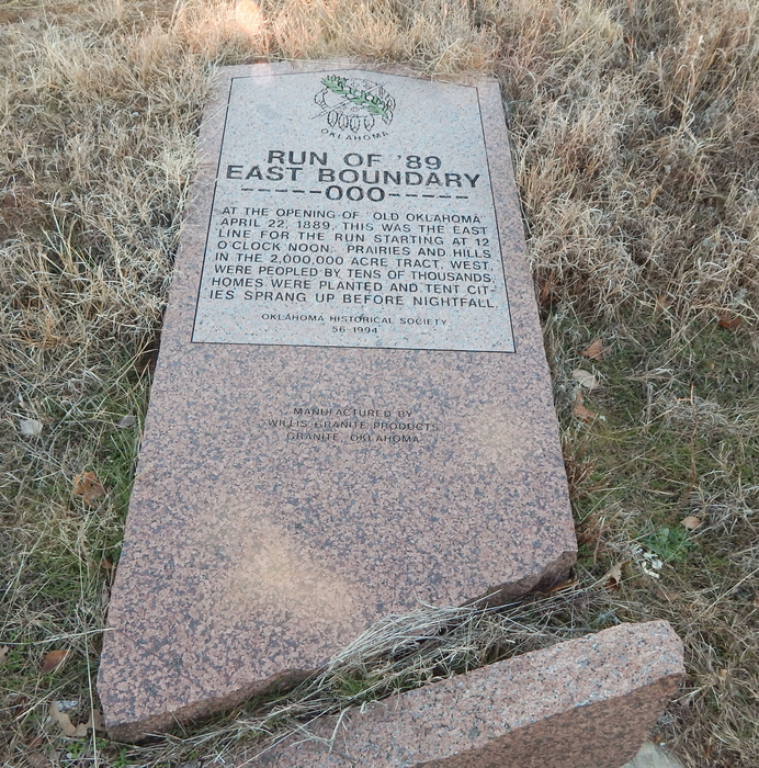
This survey marker was originally upright. It marked the eastern 1893 Oklahoma Land Run boundary.

A benchmark is a type of survey marker that indicates elevation (referring to a vertical position). Horizontal position markers used for triangulation are also known as triangulation stations. Considering the earth is a globe, not flat, and contains mountains and valleys, these details must be accounted for through triangulation.

Survey markers are also called survey marks, survey monuments, or geodetic marks. My husband, who worked almost his entire career in one aspect or another of engineering construction, called them shiners.

This particular shiner is next to Merced River inside Yosemite National Park, just after entering the toll gate on Highway 140. There is a small rest stop there. While waiting for me one year, he wandered out over the rock that overlooked the river and was pleased to find this shiner firmly embedded in the stone.

1855 Geodetisch station at Ostend, Belgium used for triangulation
Survey markers were often
placed as part of triangulation surveys, measurement efforts that moved
systematically across states or regions, establishing the angles and distances
between various points. Such surveys laid the basis for map-making across the
world.

Located on peak of Prospect Hill-Wompatuck State Park, Hingham, MA
All sorts of different objects, ranging from the familiar brass disks to liquor bottles, clay pots, and rock cairns, have been used over the years as survey markers.
Some show the meeting points of three or more countries. In the 19th century, these marks were often drill holes in rock ledges, crosses or triangles chiselled in rock, or copper or brass bolts sunk into bedrock.

Today in the United States, the most common geodetic survey marks are cast metal disks with stamped legends on their face set in rock ledges,

embedded in the tops of concrete pillars,or affixed to the tops of pipes that have been sunk into the ground. These marks are intended to be permanent, and disturbing them is generally prohibited by federal and state law.

Some old markers were buried several feet down to protect them from being struck by ploughs or disturbed by other means. Occasionally, these buried marks had surface marks set directly above them.
This year, it was my research for two books set in the new Oklahoma Territory that was formed as a result of the land runs that led to my research on survey markers.
In 1871, the internal format of Oklahoma, then the Indian Territory, began to take shape. Based on Thomas Jefferson's standard United States public land survey system of townships, ranges, sections and quarter sections, an Initial Point was selected and a grid work of north-south and east-west lines was established. The entire Indian Territory was surveyed from a "bearing point" located one mile south of Fort Arbuckle and eight miles west of present-day Davis.

Survey crew Cherokee Strip (Outlet)
I have not discovered
exactly what style of survey marker was used when the Cherokee Outlet was
divided into quarter sections or city lots for those new cities that were planned
in preparation for the 1893 land run. I’m sure they were set in a manner to
avoid being disturbed or removed.
However, in my book, Joshua’s Bride, my fictional heroine, Rose Calloway, attempted to secure the survey marker on the back, out of the way corner of the homestead plot she claimed. Being told by two of her neighbors who shared the corner that it was illegal for her to remove the survey marker did not deter her from digging it up. She was determined to keep usurpers from coming onto the back portion of her land and copying down the coordinates in an effort to claim the homestead plot for themselves. Here is an excerpt from the book:
“You need to put it back, right away. In fact, give it me. I’ll find a surveyor and have him reset it.” The clerk reached for the pole.
“No!” Rose twisted to keep the post away from his reach. “It’s my pole that goes to my property. Well, mine and three of my neighbors.”
“Sir, you won’t need to go to all that trouble.” Joshua pulled Rose behind him and stepped to squarely face the clerk. This woman needs a keeper. “She’s with me, and I’ll help her return it where it goes.”
“She your wife?”
“No, sir, she’s my fiancé. We have one more matter of business to see to while we’re here, and then I’ll return her home and help her reset it.” The word fiancé was out of Joshua’s mouth before he even thought about it. He did not know how she felt about it, but, he reasoned, it was better for her reputation to be traveling in the company of a fiancé than a man with whom she had a casual acquaintance. He held the clerk’s gaze.
“Is there a problem, Charlie?” A deep voice sounded as an older, thick-shouldered man with a deputy marshal’s badge on his chest approached.
“This woman here—” The sputtering clerk waggled a finger at Rose as he turned his head to toward the deputy marshal.
“There’s just been a little misunderstanding, marshal.” With a smile that lit her entire face, Rose stepped back to Joshua’s side. “I brought this survey post with me to help me register my land. You know, to prove I am the one who has the claim on that particular homestead? However, the clerk just told me I wasn’t supposed to take it out of the ground. I assured him I will take it home and put it back where it goes.”
Joshua shifted his gaze between Rose, the deputy marshal with the thoughtful expression, and the clerk, who rolled his eyes. He resisted the urge to roll his eyes, too. I want to be her keeper. He cleared his throat. “As I was telling this gentleman, here…” he gestured toward the clerk. “Now we know the pole needs to stay in place, we’ll leave as soon as we finish one more item of business and go directly to the property where this survey post goes. I’ll help her get it set in the ground properly.”
“Sounds reasonable to me.” His hands on his hips, the deputy marshal pressed his lips together and nodded. “Work for you, Charlie?” He turned to the clerk with an expression that did not invite a challenge.

As he stared at the deputy marshal,
Charlie swallowed. “If you say so.” Then he stiffened his posture as he turned
and scowled at Rose. “Swear you’ll put it back as soon as you return to the
property.”
“I don’t swear, sir.” Rose straightened her spine and lifted her chin. “But, I will promise. I will return home and put the pole back where I found it.”
Joshua’s Bride is available for sale as an ebook and a paperback. It is also available at no additional cost with a Kindle Unlimited subscription. You may find the book description and purchase link by CLICKING HERE
 Rose’s sister, Marigold Calloway, claimed two lots in the
town of New Ponca that was created as part of the same 1893 Cherokee Outlet
Land Run. Even the boundaries of many town lots are marked with survey markers.
You may find the book description and purchase link of Marigold by CLICKING HERE
Rose’s sister, Marigold Calloway, claimed two lots in the
town of New Ponca that was created as part of the same 1893 Cherokee Outlet
Land Run. Even the boundaries of many town lots are marked with survey markers.
You may find the book description and purchase link of Marigold by CLICKING HERE
Sources:
https://en.wikipedia.org/wiki/Survey_marker
https://libraries.ok.gov/state-government/corner-monuments/
https://en.wikipedia.org/wiki/1877_survey_marker_48
No comments:
Post a Comment
Thank you for visiting Sweethearts of the West! We are very sad to require comment moderation now due to the actions of a few spam comments. Thank you for your patience.