Showing posts with label Tuolumne County. Show all posts

Sunday, October 1, 2023

Formation of Tuolumne County, California by Zina Abbott


On February 18, 1850, Tuolumne County was established by the California Legislature as one of the original twenty-seven counties. It was given its name and divided into the six townships of Sonora, Mormon Camp, Jacksonville, Don Pedro’s Bar and Tuolumne City. It had it white American roots in the gold rush.
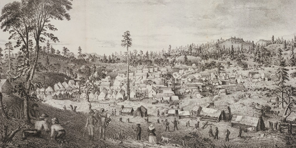
 

1852 Columbia, California

The name Tuolumne is of Me-Wuk, or Mi Wuk, (the predominant Native American tribe in the region) origin. It has been given different meanings, such as "Many Stone Houses," "The Land of Mountain Lions." and "Straight Up Steep," the later an interpretation of William Fuller, a native Indian Chief. Vallejo, in his report to the first Legislature, said that the word is “a corruption of the Indian word talmalamne which signifies “cluster of stone wigwams.” The name may mean “people who dwell in stone houses,” i.e., in caves.


This is interesting, since the Mi Wuk tended to live in cedar bark shelters.

1851 California mining map showing counties

Originally, it was much larger than it is now. When the state was organized in 1850, Tuolumne was. At the time, it was far larger than it is now.  It extended from the summit of the Coast Range on the west. It was south of San Joaquin County and extended eastward to the summit of the Sierra Nevada Range. It included all of what is now Tuolumne County, Stanislaus County, and parts of other counties.

At the first California Legislature meeting in 1848-1849, what became known as the town of Sonora, which had been named after the Mexican state of Sonora, became the county seat of Tuolumne County. At first, due to the large number of gold miners from Sonora, Mexico, who had come to work the region, it was known as Sonora Camp.  When Malcolm M. Stewart, who represented the San Joaquin district in the Assembly, went to that first meeting, he called the town “Stewart, formerly known as Sonorian Camp.”  The name was changed back to Sonora by petition and an amendment approved by the State Senate on April 18, 1850.  By May 1851, the city of Sonora was incorporated.

July 7, 1852, the first meeting of the Board of Supervisors of Tuolumne County was held.


June 1854, Stanislaus County broke off from Tuolumne County, and that county held its first elections. Tuolumne became much smaller in territory.


There is a Tuolumne City in Tuolumne County. However, it has never been the county seat.


It was not long before this county became known for its gold production, timber and lumber, and agricultural production.

Bret Hart Cabin and Hanging Tree in Big Oak Flat

The following is a list of early cities, towns, and communities in Tuolumne County. The names that are bolded are the ones in which I have set some of my books. Big Oak Flat, Chinese Camp, Columbia, Groveland, Jamestown, Long Barn, Mi Wuk Village, Moccasin, Pinecrest, Sonora, Soulsbyville, Standard, Strawberry, Tuolumne, Twain Harte.


Willow, my heroine in my latest release, 

A Watchman for Willow

came from a lumber camp in the east part of Tuolumne County to Sonora after her husband died. To find the book description and purchase options, please CLICK HERE


Sources:

https://scholarlycommons.pacific.edu/cgi/viewcontent.cgi?article=1945&context=uop_etds

The Early History of Tuolumne County California.pdf

https://archive.org/details/historyoftuolumn00lang/mode/2up

https://en.wikipedia.org/wiki/Tuolumne_County,_California

https://www.tchistory.org/TCHISTORY/TCTimelines_1851_1900.htm

https://tchistory.org/california-statehood-establishment-of-tuolumne-county/

https://geographic.org/streetview/usa/ca/tuolumne/index.html

https://www.counties.org/county-profile/tuolumne-county


Thursday, December 30, 2021

Chinese Walls by Zina Abbott


When I first moved from Los Angeles to the San Joaquin Valley in the 1970’s, on my first road trip to Sonora in the Mother Lode foothills to the east, I noticed, first, that there was a lot of rock that looked almost volcanic. I also noticed the fields of the rolling hills were covered with walls made of the black basalt rock. I was told these are called “Chinese Walls,” because they were built by Chinese workers in the nineteenth century.


One of the great contributions of Chinese Americans to development of California was their stone masonry skills. However, there were stone masons of other nationalities at work in the state at the time, so without conclusive documentation, one cannot be absolutely certain how many walls were built by the early Chinese.


This photograph, above, was taken about four years ago along Highway 108 to Sonora. There are very few Chinese Walls remaining along this route to the gold fields that dates back to the 1850's. Although they seemed to last from the early 1860’s to about the 1980’s, modern development coupled with a disregard for the history of the region has tended to take its toll.


These rock walls, which date back to the early 1860's, built with field stone or river rock, are also called "Chinese Walls" because they are believed to have been constructed by Chinese laborers. Several instances of reports of work crews by Chinese laborers might be found in the Mariposa Gazette, the county’s newspaper which dates back to the 1860’s. These stone walls meander through Mariposa County in lines that define the contours of the land. They can often be seen from more modern roads, such as the one in the photograph above. I took this picture and the one used for the post header a mile or so south of Highway 140 to the west of Mariposa.

The stone walls on the Quick Ranch is well documented as having been built by Chinese workers under a Chinese contractor, since the ranch has remained in the family of the founder for six generations. They serve as a prime example of Chinese stone masonry technique and can be used to help identify other Chinese stone walls throughout the state. Unfortunately, in my opinion, this historic photograph of this wall, which was about four feet in height, and used to contain and separate the ranch’s livestock, visually leaves a lot to be desired.

The Quick Ranch sits in the rolling foothills along the former Raymond-Mariposa Road. The original plank house that dates to the 1850s still stands. The ranch is now owned by Clyde E. Quick, the great-grandson of the founder, Morgan W. Quick.

In 1849, Morgan Quick, at the age of 21, sailed from New York to California, then traveled to Mariposa to mine gold. In 1859, Morgan bought a homestead 11 miles south of Mariposa for $250. The 160-acre property was located on Rancheria Creek, surrounded by a common brush fence. The highest hill on the ranch is 2,022 feet. Altogether, including various home steads, the ranch covered 4,000 acres. Remains of the homesteads are still on the ranch.

In 1862, Morgan Quick had a rock wall built. This not only kept the livestock in but cleaned the fields of rocks. Cattle, horses, hogs, turkeys, and chickens were raised over the years. The family grew their own barley and wheat, and harvested wild oat hay.

Chinese workers from Mormon Bar built the fence under the direction of a Chinese boss. Morgan also agreed to feed the workers and bought a herd of hogs at about a cent and a half a pound to provide pork. Most of the original wall is still standing. Although other parts of the ranch remain, one of Morgan Quick's greatest monuments is the rock wall.

From the 2008 Sierra Sun Times article, “Chinese Walls,” By Rochelle Frank:

Morgan Quick agreed to pay a Chinese contractor $1.75 for each rod (sixteen and a half linear feet) of stone wall. He also provided pork and rice for the workers. The contractor, who sat under an umbrella tracking construction progress with an abacus, paid his workers 25 cents per day IF they completed a rod and a half (twenty four feet and nine inches). The daily wage was lost if workers failed to meet the quota. 

The whole project, about four miles of stone wall, took almost a year to complete and cost the rancher $6,000.

The workers cleared fields of stones and used them to build four foot high barriers that marked property boundaries and formed cattle enclosures. No mortar was used to hold the wall together. Skillfully stacked, the uncut stones were carefully placed to slope inward on each side. Being about two feet wide at the bottom, they tapered up to one foot wide at the top. Some of the walls still serve their original purposes today, where an addition of stakes and barbed wire have been incorporated into the original stone foundations.

 ~o0o~

Although Mariposa County is not featured in my book in the Bachelors & Babies series or my two in the Cupids & Cowboys series, it is the county immediately to the south of Tuolumne County, of which Sonora is the county seat. However, the basalt rock Chinese Walls along what was originally the Old Sonora Road would have been seen by Cole, Madeline, and their parents as they traveled between Knights Ferry and Sonora. Below are the links for these books.


Kendrick http://mybook.to/Kendrick-BnB

Cole - http://mybook.to/Cole-CnC

Madeline - http://mybook.to/Madeline


Sources:

https://www.nps.gov/parkhistory/online_books/5views/5views3h65.htm

http://www.goldrushcam.com/2008/LG/sierra_sun_times%20linda%20gast%205.htm